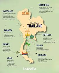
Thailand Map: Your Ultimate Travel and Navigation Guide
Thailand, famously known as the “Land of Smiles,” is a Southeast Asian country that attracts millions of tourists every year with its rich culture, vibrant cities, stunning beaches, and lush landscapes. For travelers, researchers, or anyone planning to explore Thailand, understanding a Thailand map is essential. This guide will help you navigate the country effectively, highlighting its regions, key cities, landmarks, and transportation networks.
Overview of Thailand
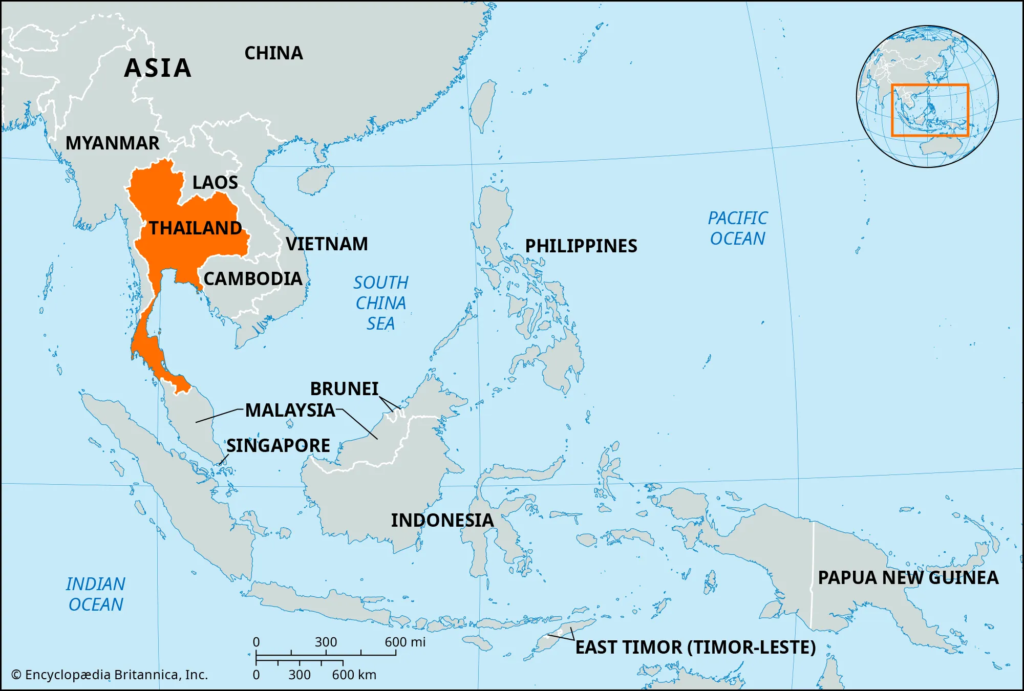
Thailand is located in the heart of Southeast Asia, sharing borders with Myanmar to the northwest, Laos to the northeast, Cambodia to the southeast, and Malaysia to the south. The country covers an area of approximately 513,120 square kilometers, making it slightly larger than Spain. Its diverse geography includes mountains, plains, plateaus, rivers, and an extensive coastline along the Gulf of Thailand and the Andaman Sea.
Thailand is divided into six geographical regions: Northern Thailand, Northeastern Thailand (Isan), Central Thailand, Eastern Thailand, Western Thailand, and Southern Thailand. Each region has its own unique geography, culture, and attractions.
Understanding the Thailand Map
A Thailand map is a visual representation of the country’s physical features, cities, roads, and regions. It is essential for both tourists and locals for travel planning, logistics, and educational purposes. Thailand maps can be broadly categorized into:
- Physical Map of Thailand – Shows mountains, rivers, and natural features.
- Political Map of Thailand – Shows provinces, cities, and borders.
- Tourist Map of Thailand – Highlights attractions, beaches, national parks, and landmarks.
- Transportation Map of Thailand – Displays airports, railways, highways, and bus routes.
Using these maps together gives a complete understanding of Thailand’s geography and travel options
Northern Thailand
The northern region of Thailand is known for its mountainous terrain, cool climate, and cultural heritage. Chiang Mai and Chiang Rai are the major cities in the north and popular tourist destinations.
Key Features on the Northern Thailand Map:
- Chiang Mai – The cultural capital of Thailand, famous for temples, night markets, and mountain trekking.
- Chiang Rai – Known for the White Temple (Wat Rong Khun) and scenic hills.
- Mae Hong Son – Offers picturesque landscapes and traditional hill tribe villages.
- Doi Inthanon – Thailand’s highest peak.
The northern region is ideal for travelers seeking adventure, nature, and cultural experiences.
Northeastern Thailand (Isan)
Northeastern Thailand, or Isan, is the country’s largest region and is characterized by vast plateaus, rivers, and rural landscapes. It is less touristy but offers a deep insight into authentic Thai culture.
Highlights from a Northeastern Thailand Map:
- Udon Thani – A major city and gateway to historical sites.
- Khon Kaen – Known for education and cultural events.
- Nakhon Ratchasima (Korat) – The region’s largest city, famous for Phimai Historical Park.
- Mekong River – Forms a natural border with Laos.
Isan is famous for its traditional festivals, sticky rice dishes, and historical sites.
Central Thailand
Central Thailand is the political, economic, and cultural hub of the country. Bangkok, the capital city, is located in this region. A map of central Thailand highlights major rivers, roads, and urban centers.
Important Cities and Features:
- Bangkok – Thailand’s largest city, famous for temples, palaces, shopping, and nightlife.
- Ayutthaya – Historic city with ancient ruins and UNESCO World Heritage Sites.
- Kanchanaburi – Known for the River Kwai and WWII history.
- Chao Phraya River – Major waterway supporting agriculture and tourism.
Central Thailand is well-connected by highways and railways, making it easy to explore other regions.
Eastern Thailand
Eastern Thailand is home to beautiful coastlines, islands, and industrial cities. It is famous for beaches and seafood.
Key Locations on the Eastern Thailand Map:
- Pattaya – Popular beach destination with nightlife and water sports.
- Rayong – Known for seafood and coastal attractions.
- Chanthaburi – Famous for gem markets and tropical fruits.
- Koh Samet – A small island with pristine beaches.
This region is perfect for tourists seeking relaxation, adventure sports, and island hopping.
Western Thailand
Western Thailand is characterized by dense forests, waterfalls, and wildlife sanctuaries. It is less populated and offers opportunities for ecotourism.
Notable Places:
- Hua Hin – A beach town popular with locals and tourists.
- Kanchanaburi – Shared with Central Thailand; known for Erawan National Park.
- Sai Yok National Park – Famous for waterfalls and caves.
A Western Thailand map is often used by travelers interested in trekking, nature photography, and wildlife experiences.
Southern Thailand
Southern Thailand is famous for tropical islands, beaches, and marine tourism. It is a paradise for beach lovers and scuba divers.
Key Destinations on the Southern Thailand Map:
- Phuket – Thailand’s largest island, famous for resorts and nightlife.
- Krabi – Known for limestone cliffs, Railay Beach, and Phi Phi Islands.
- Koh Samui – A tropical island with luxury resorts and vibrant nightlife.
- Trang and Satun Provinces – Less touristy, perfect for pristine beaches.
The southern region is divided by the Gulf of Thailand on the east and the Andaman Sea on the west, making it an ideal region for maritime activities.
Thailand’s Transportation Network
A Thailand map also shows major transportation routes, making it easier to plan your trip:
- Airports – Bangkok’s Suvarnabhumi and Don Mueang airports, Phuket, Chiang Mai, and Krabi airports serve both domestic and international flights.
- Railways – The State Railway of Thailand connects major cities like Bangkok, Chiang Mai, and Surat Thani.
- Highways – Thailand has a network of highways connecting all regions, suitable for road trips and bus travel.
- Ferries and Boats – Essential for traveling between islands in the south.
Using a detailed map with transportation routes helps travelers save time and avoid confusion.
Tips for Using a Thailand Map
- Choose the Right Type of Map – Depending on your purpose, select a physical, political, tourist, or transportation map.
- Mark Your Destinations – Highlight cities, national parks, and beaches to create a visual travel plan.
- Check Distances – Thailand is larger than it appears; understanding distances can prevent overpacking your schedule.
- Use Digital Maps – Google Maps, Apple Maps, and other apps offer live navigation, which is useful for real-time travel updates.
- Combine Maps – For a complete experience, use a combination of physical and tourist maps to explore both nature and cultural sites.
READ ABOUT:
Top Cities in Thailand to Visit: A Complete Travel Guide
Conclusion
A Thailand map is more than just a tool—it’s a gateway to exploring the country’s diverse culture, landscapes, and experiences. Whether you are a tourist, researcher, or student, understanding Thailand’s geography through maps makes traveling easier and more enjoyable. From the mountainous north to the island-filled south, from bustling Bangkok to serene rural Isan, a map can guide your journey through the “Land of Smiles.”
By keeping a Thailand map handy, planning your trip, exploring hidden gems, and navigating the country becomes simple and efficient.
FAQ:
Q1: How many regions are there in Thailand?
A1: Thailand has six main geographical regions: North, Northeast (Isan), Central, East, West, and South.
Q2: What is the best map to use for tourists in Thailand?
A2: A combination of tourist maps and transportation maps is ideal for planning sightseeing and travel routes.
Q3: Which city is the capital of Thailand?
A3: Bangkok is the capital and the largest city of Thailand.
Q4: Are there digital maps available for Thailand?
A4: Yes, Google Maps, Apple Maps, and other apps provide detailed navigation and live updates for Thailand.
Q5: Which region of Thailand is best for beaches and islands?
A5: Southern Thailand, including Phuket, Krabi, and Koh Samui, is famous for beaches and island tourism.